Urban Transport Policy and Land Use Planning Accessibility Nexus in Nairobi City
Research paper by Silvester Kasuku, Samuel Akatch, Francis Gichaga, Romanus Opiyo and Rose Musyoka
Abstract
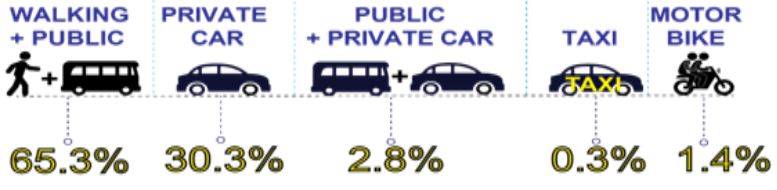
The evolution of urban transport policy in Nairobi City has followed the four primary land use planning regimes, from the colonial development containment (1948-1973) to the city expansion plan (1973-2000), the use of single issue plans to champion densification and intensification (1979-20022), Thorten (1948), Nairobi City Council (1972) the NUIPLAN (2014) and currently the National Land Use policy (2017). This study evaluates the integration of urban transport policy and land use planning in Nairobi City. The study analyses accessibility characteristics of journey time, travel time, travel speed, cost of travel, and journey length in Nairobi city. The research uses both primary and secondary data sources to analyse how accessibility is affected by the integration of urban transport policy and land use planning in Nairobi City. The variables measured included journey time, Levels of service on roads during peak times, transportation cost decay analysis, and changes in built-up areas along the Thika Road and Ngong Road Corridors. Further, the study analyses the institutions responsible for urban transport policy and land use planning in the study area. The data was analysed and interpreted to provide reliable information used to develop a model for integrating urban transport policy and land use planning. The study has found out that despite the urban transport policy and land use planning efforts, there is poor integration of urban transport policy and land use planning that has led to poor accessibility in the study area. The study has recommended and developed a model using a systems approach based on Transit Oriented Development (TOD) for the integration of urban transport policy and urban land use planning in order to achieve accessibility in Nairobi City and other similar cities in developing countries.